A groundbreaking new technology has been developed that uses artificial intelligence (AI) to detect hidden elephants in satellite images. The technique is designed to support conservation organizations in their efforts to protect these magnificent animals. Satellites equipped with cameras and sensors have become one of the most important sources of information for scientists in recent years. They have been used to document a lava lake in the Antarctic ice, the melting of glaciers, and the global deforestation of forests. Now, researchers from the University of Oxford and the University of Bath have used AI to identify elephants in the wild from satellite images for the first time.
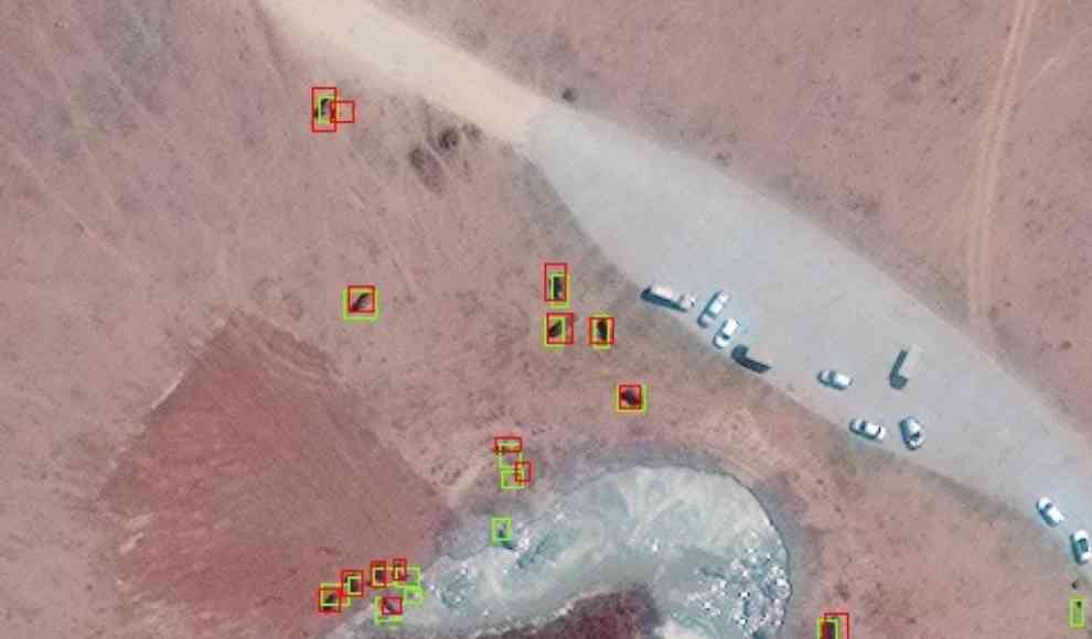
Currently, the African elephant population is mainly determined by manually analyzing aerial photographs taken from planes or drones. However, this method is time-consuming and prone to errors. Conservation organizations usually only fly over a portion of the area due to cost constraints, and the actual number of elephants is extrapolated from the observation data. Additionally, experts often count the same animals twice, leading to duplication. While research has been ongoing for several years to transfer established image processing techniques to satellite images, this has mainly been done to detect natural disasters. The recognition of animals in satellite images is still done through simple optical analysis, which can only identify particularly large animals such as whales in the sea or colonies such as penguins in the Antarctic. Elephants, on the other hand, have been difficult to identify because they move through grasslands and forests and wallow in mud, causing their color and shape to constantly change.
To solve this problem, researchers used a convolutional neural network trained with images from the Worldview 3 and 4 satellites. The system was able to independently identify African elephants with high accuracy and distinguish details with a minimum size of 32 centimeters. This breakthrough could reduce the time it takes to determine the African elephant population from several weeks to just a few hours. However, the high cost of existing satellite images, which cost $17.50 per square kilometer, and new satellite images, which cost $27.50 per square kilometer, make it difficult to implement the technology on a large scale.
In conclusion, the development of AI technology to detect elephants in satellite images is a significant breakthrough in conservation efforts. It has the potential to revolutionize the way we monitor and protect wildlife, but the high cost of satellite images remains a significant obstacle.