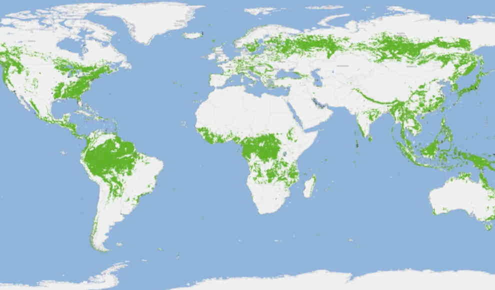
The German Aerospace Center (DLR) has created a global map showing the state of forests using 400,000 data sets. Over the past 70 years, humans have destroyed about 50% of the world’s forests. The DLR created the global forest map for the first time as part of the TanDEM-X project, which aims to create a highly accurate, three-dimensional model of the Earth. The map was created using satellite data that was combined by scientists to form a global TanDEM-X forest map. The map will help to show deforestation in rainforests in Africa, Southeast Asia, and South America, as well as document the overall state of forests. Currently, one-third of the planet’s land area is covered by forests, which is half of what it was in the middle of the last century.
The comprehensive data will help protect the last untouched forests, such as those in the Amazon, from illegal logging to preserve the Earth’s carbon stores. The data for the global forest map comes from satellites equipped with radar technology, which allows images to be created regardless of weather and time of day. This is particularly advantageous for documenting rainforests, which are almost constantly covered by clouds. The processing of the extensive database was carried out by an artificial intelligence (AI) specifically developed for this purpose. The map is based on 400,000 data sets that the satellites captured between 2011 and 2015. The algorithm that processed the massive amount of data and filtered out the necessary information about the forests was published in the Remote Sensing of Environment journal.
The scientists also used data from the Global Urban Footprint, which records human settlements created by the DLR at the Earth Observation Center (EOC). Additionally, data from the European Space Agency’s Climate Change Initiative was used, which provides information on global water bodies. In the future, the planned Tandem-L satellite mission could provide weekly updated forest maps that allow for real-time observation of deforestation. The global forest map is a crucial tool in the fight against deforestation and the preservation of the Earth’s natural resources.