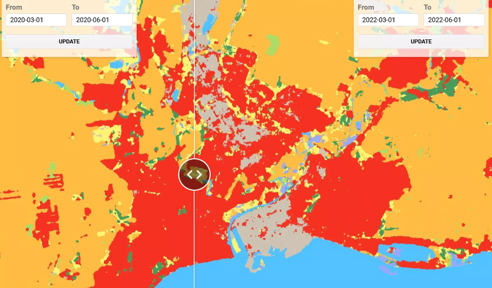
Google has released a new mapping tool called Dynamic World that shows changes to the Earth’s surface almost in real-time. Using satellite data with a resolution of 10 meters per pixel, Dynamic World can display whether there is snow and ice, water, flooded vegetation, built-up areas, trees, crops, bare ground, grass, or shrubs on the Earth’s surface. This is made possible by artificial intelligence (AI) that analyzes satellite images from the European Space Agency’s Copernicus Earth observation program. The tool receives over 5,000 new images from Sentinel satellites daily, and the AI analyzes them almost in real-time. The dataset is not only extensive but also more up-to-date than similar projects, making it useful for assessing the impact of natural disasters and other events on the Earth’s surface.
Dynamic World can compare two time periods, allowing natural processes and changes caused by humans to be visualized. The tool can be accessed for free on dynamicworld.app, and users can view data for any region of the planet and any time period. The developers of Dynamic World have explained in the scientific journal Nature Scientific Data that the tool can be used to view the destruction caused by the Russian army’s attacks in Ukraine. This makes Dynamic World not only useful for science but also for politics.
In conclusion, Dynamic World is a powerful tool that can show changes to the Earth’s surface almost in real-time. It uses satellite data and AI to analyze images and display information about the Earth’s surface. The tool is useful for assessing the impact of natural disasters and other events on the Earth’s surface, and it can be accessed for free on dynamicworld.app. Dynamic World is not only useful for science but also for politics, as it can be used to view the destruction caused by conflicts and other events.